SOURCES
What this reconstruction of New Amsterdam in 1660 rests on: the period maps and views, the written record, the modern data, and the assets and recordings. Each entry says what it was actually used for. Where something was taken from memory, inferred, or invented, it says so.
surveyed / measureddocumented in the recordinferred from Dutch practiceinvented for the model
Maps, plans and views
Castello Plan laid over the game's map


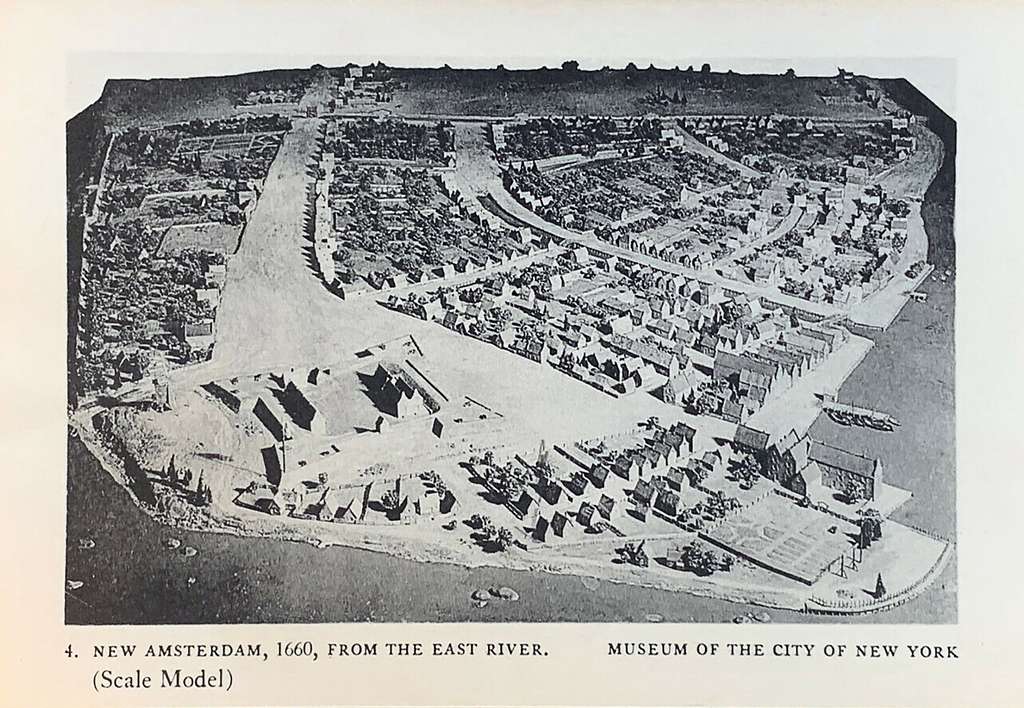
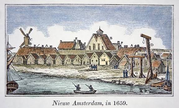


Other reconstructions looked at
| Reconstruction | What it changed here |
|---|---|
| New Amsterdam History Center, Mapping Early New York: the 3D model of the Castello Plan and its stills of the dock, the Strand and the Kierstede house | The waterfront was rebuilt after these: the East River shore is a plank-and-post sheet-piled quay (the schoeyinge) with level made ground behind it instead of a grass bank and a beach; the pier has its hoisting frame; goods are landed on the quay and boats lie against the piling. Their images are theirs and are linked, not copied. |
| NYC Municipal Archives, New Visions of Old New York (video of the Heere Gracht) | The canal banks were far too high (up to 7.8 m over the water at the head of the gracht). The ground along the canal is now held low, as the tidal inlet it was: about 1.7 m over the water at the bridges, rising gently to 2.4 m at the head. |
| “The Stadthuys of New York in 1679”, lithograph after Danckaerts’ sketch (above) | The half-moon battery standing out into the river before the Stadt Huys, and the piled shore either side of it. |
| “Description of the Towne of Mannadens” (1661), as quoted by the Atlas of Mutual Heritage; NYC Municipal Archives on the defences of 1653–63 | Why the half-moon before the Stadt Huys is kept in 1660 although the History Center’s model leaves it out: the 1661 description already has “a half moon of stone, where are mounted 3 smal bras guns” before the State House, and it was under repair in 1671. No source found gives its year of building, so 1660 is a judgement. |
| The Castello Plan itself, measured (above) | The Heere Gracht does not stop at its head: two narrower ditches go on from the junction, the Prince Graft up the line of Broad Street (about 0.69 of the main canal’s length on the Plan, 120 m here) and the Bever Graft west along Beaver Street (about 0.47, 83 m here). Both are now water, piled like the main canal, with plank foot-bridges by the junction. |
The written record
| Source | What it gave the model |
|---|---|
| I. N. Phelps Stokes, The Iconography of Manhattan Island (1915–28) | The identifications on the Castello Plan and the corrections listed above; the wall of 1653 as 9 planks high on 340 posts (one per rod); the pier at 87 ft; the dates of the Gasthuys and the paving of Brouwer Straat (1658). Used through notes made for an earlier version of this model. |
| Nicasius de Sille, list of houses, 1660 | The count of houses (307 inside the wall on his list; about 300 drawn on the Plan; 259 lots plus the named buildings are modelled). |
| New Amsterdam History Center encyclopedia: council ordinances | Hogs, goats and sheep loose in the town and rooting up the fort (1648–54, 1653, 1654); the cattle market of January 1659; the 1656 rule against lodging Indians overnight; Algonkian dress of the mid-17th century for the Munsee visitors. |
| Adriaen van der Donck, Description of New Netherland (1655) | Waterfowl, pigeons and turkeys; the duffel-cloth mantle. Read in excerpts (1841 translation). |
| NYC Municipal Archives, Historical Society of the NY Courts, Daytonian in Manhattan | The Stadt Huys: City Tavern of 1641–42, city hall from 1653, court above and prison below. |
| Gotham Center, “From Marketfield to the Greenmarket” | The pigs of the city; where the market stood (disputed between Bowling Green and Pearl/Whitehall). |
| The Mills Archive | The New Amsterdam mill listed as a post mill. |
| Archaeology, the Welikia Project, Governors Island | How far today’s shoreline has been pushed out since 1660 (about three blocks on both rivers; the southern half of Governors Island is 1900s fill). |
Modern data
| Data | Used for | Licence |
|---|---|---|
| OpenStreetMap | The street lines that carry the Dutch plan; today’s Lower Manhattan for the present-day view (building footprints, heights, construction dates where tagged, streets, parks); the coastline for the distant shores. | © OpenStreetMap contributors, ODbL |
| HYG star database v4.1 | The night sky: 2,321 stars to magnitude 5.3, moved by proper motion and precession to the year shown. | CC BY-SA 4.0 |
| Low-precision lunar and solar formulae (after Meeus) | Where the Moon stood and how full it was on the evening shown (15 September, 21:30 local mean time). | — |
| USGS 3D Elevation Program (3DEP), point elevations of Lower Manhattan today, sampled every 25 m | The shape of the ground: the Broadway ridge, the fall to the East River, the Broad Street hollow. It is today’s ground, not 1660’s, so it is used only on land that existed then, with two estimated corrections: low ground lowered about a metre (later fill and paving), and the knoll under the fort, levelled in 1790, put back at about the height of Bowling Green. The 1782 British Headquarters Map and the Welikia reconstruction would be better and have not been used. | |
| The Welikia Project (Wildlife Conservation Society / New York Botanical Garden): per-block elevation and ecological communities of the island in 1609 | Heights: the ridge agrees with today (Broadway at Wall Street 37 ft); the low east and south ground was at 0–2 ft, salt marsh, so the model holds it low, as made ground level with the quay. Plants: the blocks under the town were Appalachian oak-hickory forest on the high ground with low salt marsh and salt shrub at the edges; the woods north of the wall are oak, and a fringe of marsh grass stands on the shore wherever the town has not piled and filled it. The shoreline west of the fort was also corrected against it and the Castello Plan. |
Models, materials and motion
| Asset | Used for | Licence |
|---|---|---|
| Poly Haven | Photoscanned brick, roof tile, thatch, plank, cobble, earth, grass and plaster; the sky; the two Dutch ships at anchor; casks, crates, baskets and buckets. | CC0 |
| MakeHuman / MPFB2 | The bodies, skins, eyes and hair of the townspeople. Their 1660 clothing was modelled for this project. | CC0 assets |
| CMU Graphics Lab Motion Capture Database | Walking, standing, talking, sitting and sweeping motions. | Free to use; credit requested |
| Blender and three.js | Everything else was generated in Blender by script (houses, fort, wall, canal, interiors, animals) and is shown in the browser with three.js. The water ripple map is from the three.js examples. | GPL / MIT |
Sound
All of these can be auditioned, and alternatives chosen, on the sounds page.
- Recordings (surf, water, gulls, the church bell from Aldeboarn in Friesland, footsteps on wood, stone, mud and grass, the animals, city traffic) are from Wikimedia Commons and OpenGameArt. Each file, its author’s title and its licence are listed in CREDITS.txt.
- The Dutch conversations in the street were written for this project and spoken by a synthetic voice. They are in modern Dutch with an old-fashioned “gij”, about things the record supports (the hog fines, the bread assize, the ban on thatch, the Latin school, the Esopus peace). They are not transcripts of anything.
- What a townsperson says when you speak to them is generated by a language model from that person’s name, trade and concerns. It is in character, not a historical statement.
- Music is played through YouTube’s own embedded player: “Baroque Music from The Netherlands” in 1660, and a second video in the present-day view; these are not copied or re-hosted. Near the Munsee camp in the woods north of the wall the music is “Native American Flute” by Universfield, from Pixabay, used under the Pixabay Content License.
What is inferred or invented
- Which lot holds which kind of house, the colour of every front, and what is inside each house. Furnishings follow general Dutch practice of the period; no New Amsterdam household inventory of the 1650s was found.
- The height of the ground. No survey of 1660 exists; the ridge, the hollow of the canal and the strand are approximations.
- The number of people out of doors, and nearly all their names. Twenty-four are real residents of 1660; the rest are period names. There is no census for 1660 (estimates run about 1,200 to 1,400).
- The weathercocks on the church, the leftover tavern fittings in the Stadt Huys, hens in the yards, and where exactly the Munsee visitors traded.
- In the present-day view: facades are generic, and construction years are real where OpenStreetMap carries them and estimated from a building’s type and height where it does not.
